SUNDRE – Although there yet remains numerous procedural steps to be taken and discussions to be had prior to any shovels ever going into the ground, a proposed development in Sundre’s northwest is that much closer to becoming a reality.
A public hearing for the Mountain Springs area structure plan was held on June 9 with no one registered to participate by telephone and nobody attending in person to express opposition.
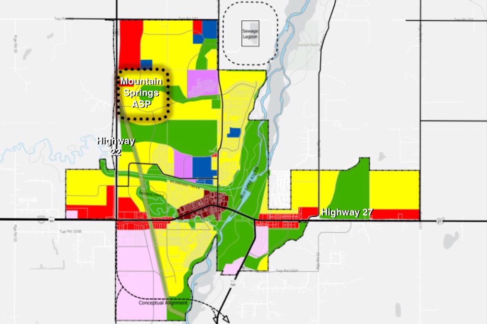
Benazir Thaha Valencia, director of community development, presented to council a report about the proposed project that was submitted by applicant Mike Mielnichuck of Collabor8 Architecture and Design Inc. who is representing the landowner, Karen Huhn.
The 155-acre parcel of land is located on Sundre’s northwestern boundary immediately east of Highway 22, and the process to develop the plan dates back several years with preliminary meetings that occurred in the fall of 2020.
“The proposed planning area in the ASP is predominantly residential with some commercial and open space,” said Valencia, adding the vision is to feature a variety of housing types ranging from starter homes to larger estate homes as well as a designated commercial area to offer essential goods and services for residents in the plan’s area as well as surrounding communities.
The application was initially submitted in September 2021, and there throughout the years since have been numerous internal reviews including policy development and discussions to address comments and concerns.
First reading was originally granted in March 2023 followed by an external agency review as well as an open house conducted by the applicant in June 2023.
“There were ongoing discussions between Alberta Transportation and the applicant regarding future access to Highway 22,” said Valencia.
“The issue was ultimately resolved, and the resulting updates to the ASP were circulated to external agencies April of this year.”
The plan outlines the density of the population proposed for the area and the general location of major transportation routes and public utilities.
Directly to the east of Mountain Springs lies the Eagle Ridge development, with Snake Hill to the southeast.
Immediately south are lands zoned urban reserve with Highway 22 to the west, while lands located north are for the proposed for the Sundre Hills area structure plan.
“It should be noted that the Mountain Springs plan area is designated as urban reserve and will remain as urban reserve until the outline plan and land use redesignation stage,” she said.
“Final uses will depend on market conditions and will be determined at land plan and land use redesignation.”
The total forecasted population at full build-out is 1,751, and a transportation impact assessment has been completed, she said.
“The internal road network has been reviewed by the town’s consulting engineers and is considered appropriate for the proposed land uses,” she said.
“It should be noted that Alberta Transportation and Economic Corridors did have concerns regarding the access point due to future speed and signalization concerns,” she added.
“A speed reduction on Highway 22 is unlikely until substantial development occurs.”
Additional traffic studies and approval from TEC for final design and location of the Highway 22 intersection will eventually be required, she said.
“In addition, coordination with the Town of Sundre and Eagle Ridge landowners will be required to align road connections – particularly at the southeast access point where the Eagle Ridge development is expected to begin first.”
Servicing connections will all flow in from the east through the Eagle Ridge area, she said, adding that “all servicing infrastructure and associated costs of the development are the responsibility of the developers.”
Although more detailed phasing is expected as the process progresses toward land use redesignation, development is expected to occur from the east and expand west depending on service connections, she said.
“It is understood that further studies and detailed planning will be conducted in the next stage of development.”
Mayor Richard Warnock was the only member of council to ask a question and inquired whether the municipality had sufficient capacity to service the proposed development.
“The next stage would be the outline plan and the land use redesignation where we will have that conversation and determine capacities and further get into more detail at the subdivision stage,” said Valencia.
Betty Ann Formstone, legislative executive assistant, read into the record the only correspondence submitted by email from an adjacent landowner to the west of Highway 22 who expressed a concern about the approach to the road.
Speaking on behalf of the family that has owned the parcel for more than 30 years, Mielnichuck said they have always intended for the land to be a development for the betterment of the community that capitalizes on spectacular views.
“We believe that what you’re looking at now and that we’ve presented is a well thought-out and comprehensive area structure plan,” he said.
With no further questions from council and no one present in the gallery speaking opposed, the public hearing was ultimately closed.
Later during the regular meeting, council adopted the area structure plan.


